Last week's post showed a practical way to create countries and provinces. The next logical step was to split the resulting regions even more and produce cities and even lots for individual buildings.
My approach as usual was to find a sweet-spot between effort and realism. I made geography the main influence to city location and layout, with some hints from cultural properties.
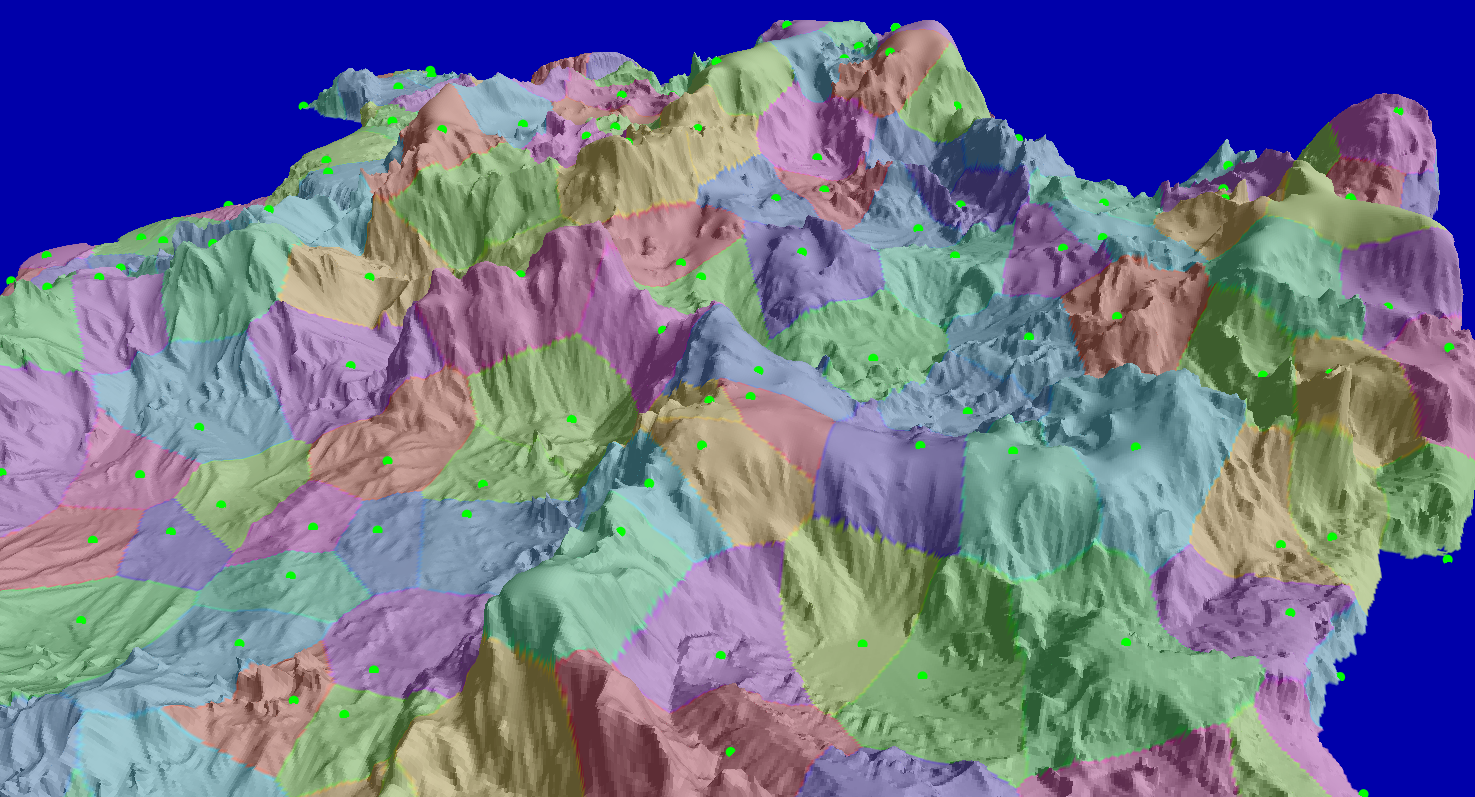
First I subdivided the regions I had found before. I added a new set of points and computed the resulting Voronoi for it:
Yes, it is quite messy, but it will clean up very nicely later. Each patch in the previous image is a few hundred meters diameter. They are roughly the size of a real-life city block.
Two things about this Voronoi phase: Seed points were placed where the slope was maximum. This is so the boundaries would end up in places where the slope was not too high.
Also the distance function is warped in the Y coordinate, which is up/down in the world. The warp makes a difference in the vertical axis weight more than a difference in the horizontal axis. This has an interesting effect on the resulting Voronoi cells. They are not convex anymore in Euclidian space, and they tend to be constrained to areas of similar altitude. Later you will see why this helps.
It is time for clean up. First I removed patches in the frontier with another province. I wanted some undeveloped space between cities.
Then I removed patches that were in steep terrain. This is controlled by a cultural parameter, since some cultures are better building on the slopes.
Here you can see the results:
It is harder to see in just a screenshot, but the resulting cities end up in mostly flat locations. They still make use of interesting places like some mountain tops or the border of a cliff. This is thanks to the peculiar characteristics of the earlier Voronoi phase.
Next I extended the roads so the city blocks would be connected to the main road system:
At this point I had the city mapped out. The next step was to break down each block and determine the location of individual buildings.
There was one hairy problem. All this generation so far was done in two dimensional arrays, where each cell of the array was roughly 5 meters wide. My architecture system, on the other hand, is based on vector shapes. Somehow I needed to convert the 2D maps into shapes before I could feed building locations and sizes to the architecture layer.
The first step was to clean the 2D map. I filtered it to make sure there were no weird pixel configurations ending in non-manifold shapes. I also made it all just two values: 0 for empty and 1 for taken. The following image shows the resulting bitmap for one area:
So it was about converting a map of bits into polygonal shapes. I wonder where did I hear that before?
At the beginning of this project I considered representing voxels just as bits and then produce
smooth polygonal surfaces by using mesh relaxation. I did not use that method for the virtual world at the end, but all the work I did back then became really helpful for this task. It was pretty much the same problem, only in 2D.
The first step was to create a Lattice of points, but only for those cells in the boundaries; that is, when the 1 became a 0 or the other way around:
Next I applied my old smoothing algorithm to the lattice grid. For each point a new position is computed based on the two other points that are connected to it. After enough iterations it not only becomes smooth, it actually flattens out and sharp features appear.
Even if sharp and flat, there were a lot of vertices in the resulting polygons. I used some form of greedy simplification to take them out:
Not bad. While it is all polygons now, this is still far from what the architecture system can take.
In this system, buildings start from what it's called a "scope", which is pretty much a 3D box with some orientation. Even round buildings start from a scope. Some buildings may span from one scope to another, like a castle for instance, which may be composed of many scopes bound together by hallways, flying bridges, etc.
I devised several methods of cutting these polygons into boxes. Each method produces a different feel, and each one can be controlled by some parameters. All this is determined by the culture settings of the city.
These methods work in two phases. First they subdivide polygons until they are roughly square:
And then they output actual boxes for building scopes:
In this last image the boxes appear in black. This is where the buildings will be.
As you can see, the buildings closely follow the roads and make good use of the space available. Not every block has to be filled with buildings. Depending on cultural or even random factors, there could be parks or entirely undeveloped lots. Some further blocks could be marked as agriculture, if the climate and culture allows for it.
At this point you may be curious about how these lots would look over the terrain. It is quite cool actually, I will post soon about it. As usual I look forward to you comments and ideas.